
A lot of people have questioned how taking a small region of Fairfax and changing the land use policies to be more urban generative can really provide any benefit to our County. What is lost in this mind set is how massive the County of Fairfax really is. It doesn’t seem like it when we are on the highways and local roads and feel congested with everyone crammed in so tight, but in fact Fairfax County is one of the least dense regions of its economic strength. In other words, yes there are clearly areas in the central portions of the Country that are measurably less populated and far more desolate, but when compared to other major metro regions Fairfax is very spread out. How spread out? Well let’s just look at Tysons Corner alone, which constitutes only 1-2% of the County’s land area, and compare it to other cities in the US.

How can we start this study without first starting with New York City. Clearly Manhattan Island, and of course the city and all of its boroughs, are far larger than Tysons Corner, but not by a massive scale. This overlay of Tysons Corner shows that the land area is similar to all of midtown Manhattan. This portion of Manhattan houses over a million residents and is composed of commercial and even industrial uses, along the Hudson River. When these two images are at the same scale, as shown, you can really see the difference between the land use policy in Tysons and Manhattan even at the visual level. Massive swathes of parking and excessive right of ways for arterial roads create gashes in between buildings.
For all of that pavement we have far worse traffic than most of Manhattan at rush hour. The Midtown Tunnel to St Lukes Hospital is approximately 2.3miles apart, and similar in distance as going from the Route 7/495 ramp to the Dulles Toll Road ramp on Spring Hill. In NYC this trip during rush hour would take typically 25 minutes, or by transit in 15 minutes. In Tysons this typically takes between 25 and 30 minutes. That’s about the same amount of time, why is it worse? Midtown Manhattan moves about 4 million people per day, one way or another, while Tysons has anywhere between 150,000 to 200,000 users per day. We are a whole order of magnitude less efficient in our transportation network, and yet have spent billions in road improvements and maintenance.

Let’s look at the other end of the spectrum, Los Angeles, a city of 3.8 million, of which only 40,000 live in what is considered and shown as Downtown. Sound familiar? LA is the future of Northern Virginia if our population continues to grow, which it will as long as our job market is good. While LA has many fans for Hollywood, weather, and pop culture awareness, no one in that city promotes their traffic, walkability, cost of living, and cost of housing. These are debilitating issues that only now are being addressed in a population growing city with an increasing deficit in tax revenue versus annual budget. At the heart of the problem has been the continued neglect of downtown growth by city planners, replaced with a focus on continuing to grow outward with quick proffer contributions from sprawl style developers. While these proffer contributions help bring in a couple million dollars in little pops, it doesn’t even begin to cover the costs of the long term infrastructure maintenance obligations.

Houston Texas might be booming from the rise in petroleum prices around the world and recent increased refining demand from domestic shale deposits, but it is considered to have the worst vehicular traffic in the country. Yet, they have built more highways and road projects than any other city in the country. While Metro Washington is considering a misguided outer beltway, Houston has been there and done that, and the traffic is still the worst.
8 lanes? Try 10 lanes on the Katy Freeway which is even supplemented with 4 additional lanes of non-through access roads! Yet the traffic is still the worst. Well Houston must have a large population, they can’t help that. In fact Houston has only 2 million residents in the entire metro region, though some argue if you include counties that extend on a 100 mile radius from the center it would be closer to 5 million. If that were the case in DC the cities of Richmond, Annapolis and Baltimore wouldn’t exist, and the DC population would be just under 10 million… just for reference. The excuses keep on piling up, but the fact remains a lack of focus in planning and no central land use policy have created the conditions the city experiences, not a lack of road projects. Houston, you have a problem.

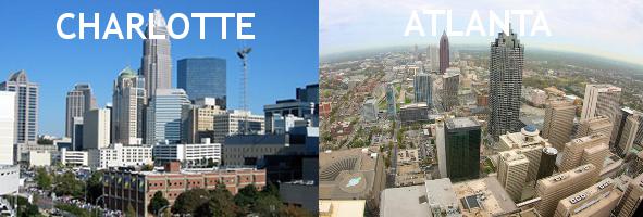
We need to cleanse our palette after LA and Houston. Charlotte, the fastest growing city in the US. Before the financial crisis it was stabilized as the 2nd financial center of the United States. The growth pangs of its economy are contrasted by its lack of growth pangs in planning. The population of Mecklenburg County, which contains Charlotte, is 1 million residents. Spot on with Fairfax County. The city of Charlotte represents 700,000 of that 1 million. Do they all live in highrises within the center of the city? No but by stifling the desires of sprawl developers to continue to grow horizontally to cheap lands, city planners created barriers that cultivated more growth closer in. The result has been a distribution of high-rises, mid-rises, townhomes, and single family detached housing wisely along transit corridors. The city planners have followed the concept of waste not want not, making it financially difficult for quick buck sprawlers who reap the benefits but provide nothing back to the community in the long term.
One might make the argument that Charlotte still has plenty of sprawl in its suburbs such as Ballantyne, Oakdale, etc. Look at these regions, and their proximity to the city. Also look at the type of development in those regions. Even in these suburbs the practices of mixed land use which allows people to walk to daily errands, good transit options, and pockets of density have reduced the impacts of this form of development. There is nothing wrong with subdivisions and single family detached housing. There IS something wrong with massive sprawl, tract style subdivisions which have no variance for as far as the eye can see, miles and miles. With proper scale and land use mixing we can create even subdivisions which have smart growth practices implemented, as Charlotte has proven. With this map you can see just how few massive road projects exist in the central city, and yet traffic in Charlotte is considered one of the best in the country for cities this size.

Finally, we’ll take a look at Charlotte’s rival, Atlanta, with a 100 year jump start on city building. Approximately the same incorporated land area as Charlotte, Atlanta has a population of 420,000 (nearly half of Charlotte) and Fulton/Cobb County, which encompass Atlanta, have a combined population of 1.5 million. Outside of these counties, another 4 million residents call the Atlanta Metro region home. Of course this spread of people, as we have seen in LA and Houston, has caused a reliance on vehicle only traffic which has pushed Atlanta to the top of the list of bad traffic cities. Yes Atlanta is a larger metro region than Charlotte, but the city itself has constant budgetary shortfalls and neglected educational and infrastructure needs because the region has escaped to far suburbs and exurbs, returning only during the day for jobs. Continued prioritization for these outside residents and their need to drive to work has choked downtown and created a cycle of failed urban planning that remains detrimental to the growth of the city.
Here are some more maps just for fun;


