Northern Virginia has faced a transportation crisis since the mid-1980s. The area retained one of the highest education, affluence, and rate of employment ranks through out the period which saw Northern Virginia turn from farmland to an economic powerhouse on par with the adjacent District of Columbia. The growth of the area acted as a snowball, consistently noted nationally for its low unemployment rate and comfortable life, and attracted more and more residents from around the country and world.
Many pined over nostalgia lost, yet no one during that period would have traded the economic prosperity they enjoyed in order to retain a fading history. Barring a negative shift in employment conditions the area was assured to continue to grow. The population of Northern Virginia(Arlington /Alexandria/ Fairfax/ Loudoun/ Prince William) grew from 900,000 in the 1980s to 1.4 million by 1990, averaging 50,000 new residents per year. The population then grew to 1.8 million by 2000, averaging 40,000 new residents per year. Today the population is 2.2 million, with an additional 200,000 residents living in further exurbs like Stafford county, many of whom commute into the inner suburbs for work. Combining suburb and exurban growth during this period Northern Virginia saw an average of 45,000 new residents per year.

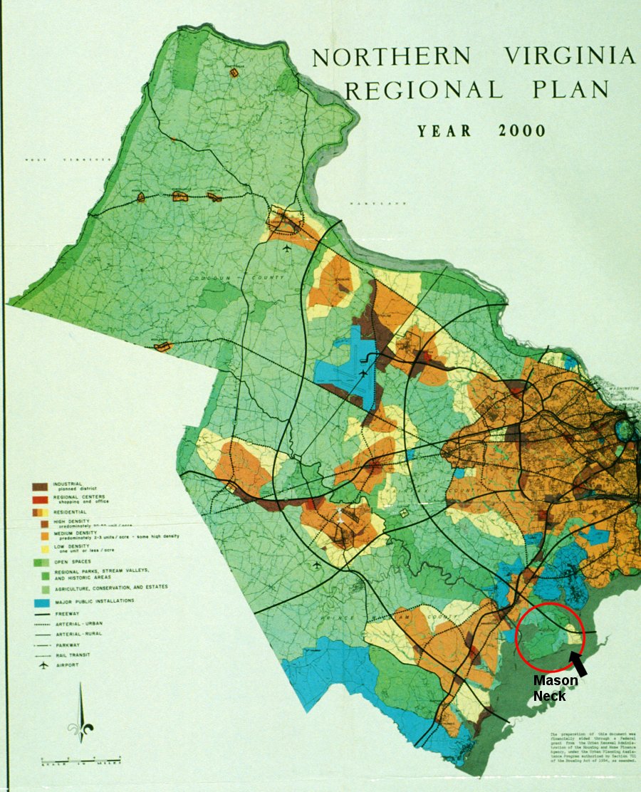
In the 1960s, a regional growth plan was created indicating where local leaders believed growth would occur in the 70s through the year 2000. In many ways this plan was successful in retaining growth in the areas anticipated. Areas around Dulles Airport saw significant growth including Reston, Herndon and Ashburn as denoted in the regional growth plan. Along I-66 growth occurred as intended in Manassas, Centreville, and Gainesville. And along I-95 growth occurred in Dale City, Burke, and Woodbridge. In the core Arlington and Alexandria both grew into urban environments.

The map to the right shows how Northern Virginia developed, with eras of growth shown in varying colors. Outward growth was rapid. An unintended consequence of the regional plan was the growth of congestion along these very routes (Route 7/267, I-66, and I-95). Transportation improvements were made in the 90s and early 2000s including the widening of I-66, I-495, and I-95 which alleviated the congestion… for a few years.
What happened next is what really changed the course of Northern Virginia. After witnessing the painful nature of the regional plans concept, expanding outward, and its subsequent cost on infrastructure, regional leaders failed to get together and discuss a future concept. Instead during the 2000s, fueled by the boom town of federal contractors, growth accelerated outwards. Town concepts around Ashburn, Herndon, and Manassas gave way to explosive sprawl which has more than overwhelmed the infrastructure improvements constructed only 10 years prior.

During the same period between the 1980s to today this area saw negligible growth in already developed areas, with exception of Arlington and remote portions of Fairfax. As new residents moved to Northern Virginia they had no choice but to continue to push the limits of a reasonable commute outward because previously developed areas were not being redeveloped.
The map to the right shows agricultural/open space (in green), low density development of less than 600 residents per square mile (in yellow), mid-density development of 600 to 5000 residents per square mile (in orange), and high-density development of greater than 5000 residents or more per square mile (in red).
Today the proverbial river is overflowing its banks. More money is coming in to address the new needs, including the 6 billion dollar Silver Line, the massive Express lane projects on I-95 and I-495, additional widening and spot improvements to I-66, and renewed fervor for an outer beltway.
What this infrastructure first concept doesn’t address is the continued lack of a land use policy, which without modifications, will once again overwhelm our regions infrastructure in a few years.

