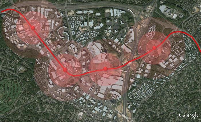
We’ve created a couple of maps for demonstrating similarities and striking differences between Arlington and Tysons, as the two are so often compared to each other. In each slider image below the aerial images have been overlain at correlating scales, with Arlington aerials encompassing the left side of the slider and Tysons the right. For the top slider distance from the metro stations is shown in concentric circles (opaque red – 1 block, dark transparent red – 1/8 mile, light transparent red – 1/4 mile, faint transparent red – 1/2 mile).
You can see, in terms of metro spacing and length of develop-able corridor, the two are similar. However, Tysons commercial business district has a far larger total area, as it extends beyond the linear regions directly adjacent to the metro stations. In Arlington, the commercial and high-rise mixed use development has been clustered almost entirely within the 1/4 mile radius, while in Tysons the existing development has been more haphazardly spread apart.
It is interesting to see that both Arlington and Tysons have obstacles to their growth in terms of highway and miscellaneous boundaries. In Arlington, GW Parkway and Route 1, to the east and adjacent to the Potomac River, create a non-pedestrian, and therefore less marketable urban zone. North of the Arlington corridor I-66, and to some extent Route 29, also create an obstructive boundary. Lastly, Route 50 to the south creates a similar boundary to Arlington.
In Tysons, like in Arlington: the Dulles Toll Road mimics I-66, I-495 mimics the eastern boundary including GW Parkway and Route 1, and Route 7 mimics Route 50. Unlike Arlington, unfortunately, Tysons is bisected to some extent by these major boundaries, specifically I-495 and Route 7. Therefore, it is very unlikely that the east side of 495 and the west side of 495 develop cohesively together, even after full build-out. It is more likely that the east of 495 portion of Tysons develops more slowly than west 495, due to the lack of height allowance, created from the proximity to single family homes, presence of defense contractors, and inability to access other portions of Tysons without vehicle or transit.
Another remarkable difference between Tysons and Arlington is the length and uniformity of each individual block. In Arlington you can see what a standard block sizing and more orderly street grid looks like. In Tysons, massive blocks (two to three times as long in each direction compared to Arlington) create impassible obstacles to non-vehicular traffic, and force vehicles to funnel to the few exit and entry points to the CBD.
From the second slider image above one can see that the area that has been developed between Rosslyn and Courthouse in Arlington is similar to the available develop-able area in North Tysons. In the Rosslyn to Courthouse corridor development has exceeded the original clustering around metro alone to create a radial development pattern. In Tysons, undeveloped land composed of mostly surface parking lots for outdated, and over-sized, office buildings make for easy redevelopment in the future. Unlike other regions of Tysons, North Tysons consists of local two and four lane roads, viable for multi-modal use. While some buildings are likely to remain for the foreseeable future (Kaiser Permanente, Gannet HQ, and Hilton HQ) others have already been noted to be temporary only, including Cityline’s PS Business Park, which is approximately the same size as all of Rosslyn.